William Bobal
Lesson One: Louisiana Purchase Map Activity
Topic: Geography of the Louisiana Purchase
Objectives:
· Learners will be able to identify which territories were included in the Louisiana Purchase.
· Learner will use KIDPIX to create a replication of the territories included in the Louisiana Purchase.
Procedures:
· Students will watch the teacher on a SMARTBOARD as she goes over the territories involved in the Louisiana Purchase. There will be two maps one showing the actual purchase and a map of the United States presently. The teacher will use KIDPIX to show how he/she wants the assignment to be done.
· The students will study the map of the territories in the Louisiana Purchase, and using KIDPIX will be able to outline the territories that turned into states from the purchase of the Louisiana Purchase.
Materials needed include:
· SMARTBOARD with projector
· Computer lab with KIDPIX on computers.
· Two maps: one showing a modern United States, and the second being the territories purchased in the Louisiana Purchase.
To accommodate students who have any needs we will slow the lesson down to help students who need more time. For any students who do not speak English we will try to bring in a bilingual teacher.
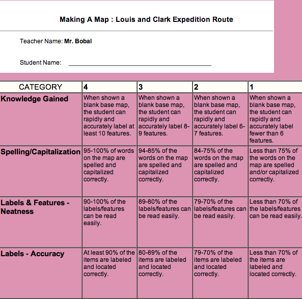
Lesson Plan Two: Louis & Clark Expedition Route Activity
Topic: Geography of Louis & Clark Expedition
Objective:
· Learner will be able to identify the route taken by Louis & Clark and map the route they used.
· Learner will be able to identify major landmarks, key stops, and other major geographical locations
Procedures:
· The teacher will use a SMARTBOARD projector to show Louis and Clarks expedition route from start to finish. The teacher will also use PREZI to show key stops along the route, geographical landmarks found during the expedition, and any other important information pertaining to the Louis and Clark expedition.
· Students will use KIDPIX again to outline the route used by Louis and Clark. Students will then use inspiration with Louis and Clark as the main circle. Students will then have three branches from the original circle and have the subcategories: Geographical locations, major landmarks, and key stops taken.
Material needed:
· SMARTBOARD with projector for all students to see.
· Computers with KIDPIX
· Inspiration
To accommodate students who have any needs we will slow the lesson down to help students who need more time. For any students who do not speak English we will try to bring in a bilingual teacher. We will also give students who need a more quite environment the option to relocate to another room.
Lesson One: Louisiana Purchase Map Activity
Topic: Geography of the Louisiana Purchase
Objectives:
· Learners will be able to identify which territories were included in the Louisiana Purchase.
· Learner will use KIDPIX to create a replication of the territories included in the Louisiana Purchase.
Procedures:
· Students will watch the teacher on a SMARTBOARD as she goes over the territories involved in the Louisiana Purchase. There will be two maps one showing the actual purchase and a map of the United States presently. The teacher will use KIDPIX to show how he/she wants the assignment to be done.
· The students will study the map of the territories in the Louisiana Purchase, and using KIDPIX will be able to outline the territories that turned into states from the purchase of the Louisiana Purchase.
Materials needed include:
· SMARTBOARD with projector
· Computer lab with KIDPIX on computers.
· Two maps: one showing a modern United States, and the second being the territories purchased in the Louisiana Purchase.
To accommodate students who have any needs we will slow the lesson down to help students who need more time. For any students who do not speak English we will try to bring in a bilingual teacher.
Lesson Plan Two: Louis & Clark Expedition Route Activity
Topic: Geography of Louis & Clark Expedition
Objective:
· Learner will be able to identify the route taken by Louis & Clark and map the route they used.
· Learner will be able to identify major landmarks, key stops, and other major geographical locations
Procedures:
· The teacher will use a SMARTBOARD projector to show Louis and Clarks expedition route from start to finish. The teacher will also use PREZI to show key stops along the route, geographical landmarks found during the expedition, and any other important information pertaining to the Louis and Clark expedition.
· Students will use KIDPIX again to outline the route used by Louis and Clark. Students will then use inspiration with Louis and Clark as the main circle. Students will then have three branches from the original circle and have the subcategories: Geographical locations, major landmarks, and key stops taken.
Material needed:
· SMARTBOARD with projector for all students to see.
· Computers with KIDPIX
· Inspiration
To accommodate students who have any needs we will slow the lesson down to help students who need more time. For any students who do not speak English we will try to bring in a bilingual teacher. We will also give students who need a more quite environment the option to relocate to another room.

Map of the territories involved in the Louisiana Purchase. The map also shows a modern map of the United States.

The route taken by Louis & Clark during their expedition after Thomas Jefferson purchased the Louisiana Purchase.